Home » Academic projects » San Cristóbal Community Ring: Urban Infrastructure For The Integration Of Hillside Neighborhoods | Architecture Thesis On Urban Regeneration
San Cristóbal Community Ring: Urban Infrastructure For The Integration Of Hillside Neighborhoods | Architecture Thesis On Urban Regeneration
Excerpt: ‘San Cristóbal Community Ring’ is an architecture thesis by Karina Nicolle Astucuri Saenz from the ‘Facultad de Arquitectura y Urbanismo – PUCP.’ The project seeks to tackle unplanned urban growth on San Cristóbal Hill through integrated planning. By creating a mid-slope ring that improves accessibility, adding community hubs, and converting risk zones into recreational and ecological spaces, it seeks to enhance safety, social cohesion, and sustainability while preserving the hill’s cultural and symbolic value.
Introduction: San Cristóbal Hill is a landmark of deep historical and cultural importance in Lima. Yet, throughout the past century, the lack of urban planning has allowed the hillside to be occupied by informal settlements. This ongoing urban expansion has created a sharp contrast between the quality of public spaces in the lower and upper parts of the hill’s eight neighborhoods. The higher areas, in particular, suffer from limited accessibility, a lack of public facilities, and greater exposure to geographical risks. As a result, street life there is fragmented and fragile.
Despite sharing the same territory, the hill is not treated or planned as a single geographic unit, highlighting the need for an integrated approach. This project embraces that challenge, proposing a ring system designed to enhance urban livability. By improving accessibility, creating new centers of activity, and developing recreational public spaces, the initiative seeks to improve residents’ quality of life and foster a stronger connection with their environment.
San Cristóbal Hill, a rocky formation located between the districts of Rímac and San Juan de Lurigancho, has held cultural and spiritual significance since pre-Hispanic times, when the Incas revered it as the protective deity of the Rímac Valley. Today, it remains the most important pilgrimage site for Catholics during Holy Week and serves as a major tourist attraction, offering panoramic views of the city.
Contrast In Habitability Conditions By Areas
A public initiative aims to boost its tourist appeal through the construction of a cable car that would ease access to the summit. However, this effort does not address the underlying issue of unregulated urban expansion along its slopes.
The first settlement on the Rímac side, Leticia, was founded in 1933, followed by Villa Fátima, Tres Compuertas, Villa Mercedes, and Vista Alegre. On the San Juan de Lurigancho side, neighborhoods such as Santa Rosita and Caja de Agua developed, together reaching a population of approximately 32,000 residents.
Spatial Fragmentation And Threats In Higher Inhabited Areas
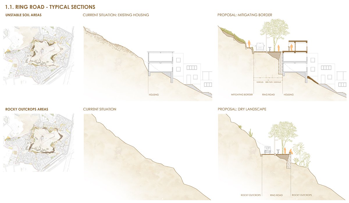
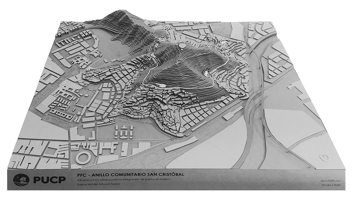
Situated on the boundary of two districts, the area suffers from weak governance, which worsens informality, insecurity, and social decline in the upper zones. To counter these challenges, a 2,125-meter ring road has been proposed, incorporating a new public transportation system, community facilities, and recreational spaces to improve urban conditions and quality of life.
Design Process
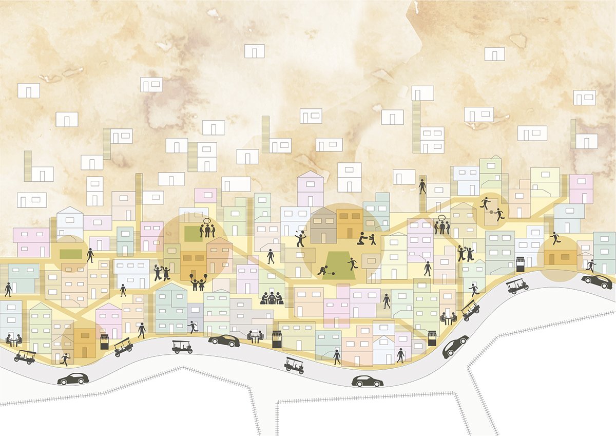
An Image That Represents The Interpretation Of Life In The NeighborhoodsA Visualization Of What The Project Wants To AchieveStrategies
The design process began with an analysis of the urban context to identify the shared challenges and strengths of the surrounding neighborhoods. Initial sketches of the ring were developed to capture the project’s central concept and later refined to adapt to the site’s geographical conditions.
Strategy 1: Articulating Accessibility Conditions Between NeighborhoodsStrategy 1: Articulating Accessibility Conditions Between NeighborhoodsStrategy 2: Generate New Centralities
The identified issues were organized into three strategies, drawing on Salvador Rueda’s habitability theory:
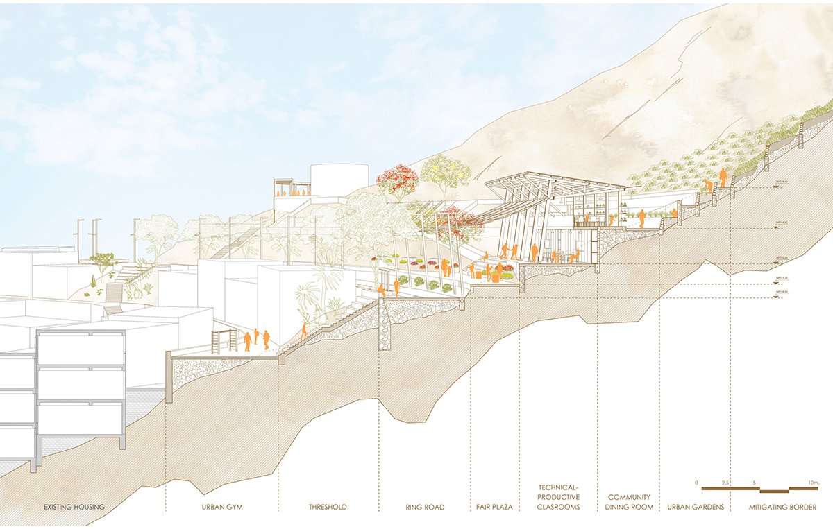
1- Improving accessibility – A mid-slope ring is proposed to contain urban growth and link the existing urban fabric. This system introduces new public transport options, including an intermediate station connected to the planned cable car, road access from major avenues, and a continuous bike path.
2- Creating new centralities – Spaces are planned to strengthen social cohesion and support essential as well as emerging community activities.
Strategy 2: Generate New CentralitiesStrategy 3: Conditioning A New Public Recreational SpaceStrategy 3: Conditioning A New Public Recreational Space
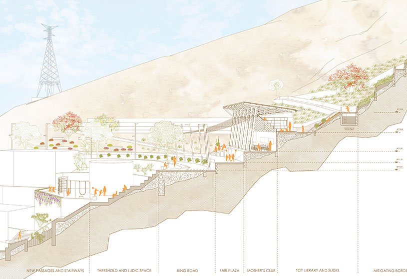
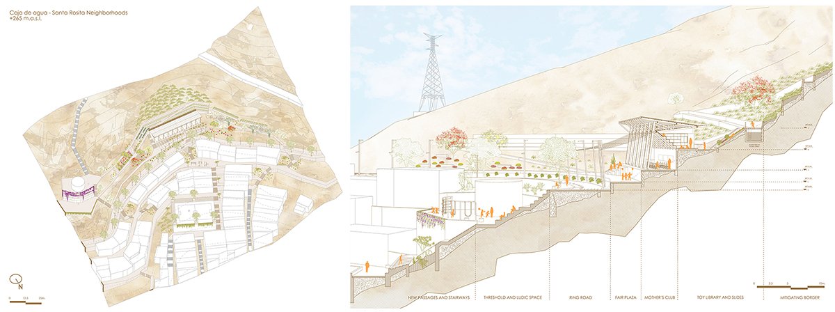
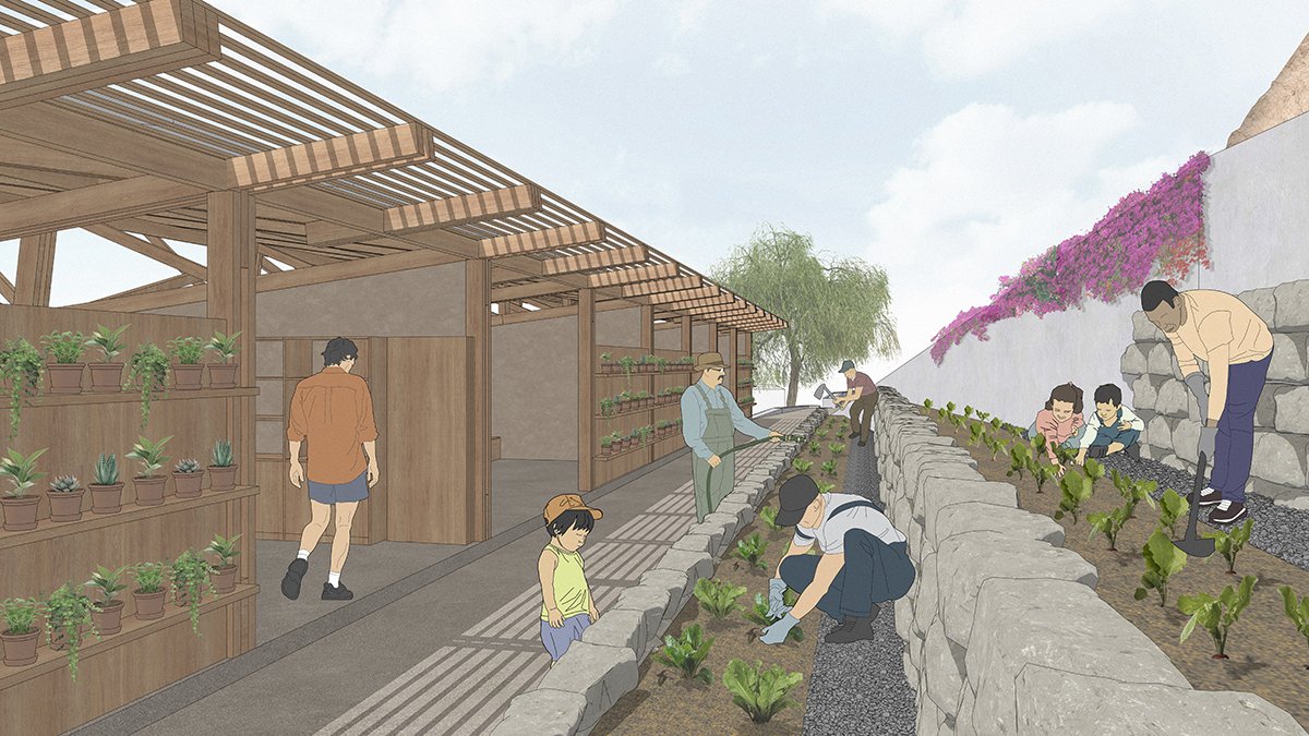
3- Reclaiming public recreational space – High-risk areas are transformed into protective green borders that double as leisure zones, offering resting spots and children’s play areas. The design integrates colorful vegetation to enrich sensory experiences. To support irrigation, greywater from household consumption is treated through wetlands and reused sustainably.
The project organizes San Cristóbal Hill into four sectors, each developed under a common framework but tailored to the existing infrastructure of its neighborhoods:
– Urban Garden Sector (Leticia neighborhood): Features classrooms dedicated to teaching planting, cultivation, and harvesting techniques.
The Youth Technical-Productive Sector | The Maternal And Child Learning SectorThe Youth Technical-Productive SectorThe Maternal And Child Learning Sector
– Artistic Expressions Sector (Villa Fátima and San Cristóbal neighborhoods): Offers workshops in painting, dance, and music to foster cultural identity and creativity.
– Youth Technical-Productive Sector (Caja de Agua and Santa Rosita neighborhoods): Focuses on developing job skills and vocational training for young people.
Ring Road And A New Urban CentralityUrban Garden LearningLudic Space
– Maternal and Child Learning Sector (Tres Compuertas, Villa Mercedes, and Vista Alegre neighborhoods): Provides a toy library for children and a mothers’ club to support family learning and community care.
Through these interventions, access to San Cristóbal Hill is structured from its entry points, activating vitality in the mid-slope zone while reinforcing the hill’s role as both a citywide viewpoint and a cultural landmark.
Project Context ModelDetail Model Of The Urban InfrastructureView Of The Project From The Metropolitan Scale
Conclusion: Ultimately, the project illustrates how integrated urban planning can offer effective solutions to the challenges of hillside settlements. Replicating and adapting such initiatives in other contexts can contribute to building more inclusive, sustainable, and equitable cities.
[This Academic Project has been published with text and images submitted by the student]
Site Context
Design Process
Final Outcome
To submit your academic project for publication at ArchiDiaries, please visit the following link >> Submit
Get the best of ArchiDiaries, directly in your inbox.
We use cookies on our website to give you the most relevant experience by remembering your preferences and repeat visits. By clicking “Accept All”, you consent to the use of ALL the cookies. However, you may visit "Cookie Settings" to provide a controlled consent.
This website uses cookies to improve your experience while you navigate through the website. Out of these, the cookies that are categorized as necessary are stored on your browser as they are essential for the working of basic functionalities of the website. We also use third-party cookies that help us analyze and understand how you use this website. These cookies will be stored in your browser only with your consent. You also have the option to opt-out of these cookies. But opting out of some of these cookies may affect your browsing experience.
Necessary cookies are absolutely essential for the website to function properly. These cookies ensure basic functionalities and security features of the website, anonymously.
Cookie
Duration
Description
cookielawinfo-checkbox-analytics
11 months
This cookie is set by GDPR Cookie Consent plugin. The cookie is used to store the user consent for the cookies in the category "Analytics".
cookielawinfo-checkbox-functional
11 months
The cookie is set by GDPR cookie consent to record the user consent for the cookies in the category "Functional".
cookielawinfo-checkbox-necessary
11 months
This cookie is set by GDPR Cookie Consent plugin. The cookies is used to store the user consent for the cookies in the category "Necessary".
cookielawinfo-checkbox-others
11 months
This cookie is set by GDPR Cookie Consent plugin. The cookie is used to store the user consent for the cookies in the category "Other.
cookielawinfo-checkbox-performance
11 months
This cookie is set by GDPR Cookie Consent plugin. The cookie is used to store the user consent for the cookies in the category "Performance".
viewed_cookie_policy
11 months
The cookie is set by the GDPR Cookie Consent plugin and is used to store whether or not user has consented to the use of cookies. It does not store any personal data.
Functional cookies help to perform certain functionalities like sharing the content of the website on social media platforms, collect feedbacks, and other third-party features.
Performance cookies are used to understand and analyze the key performance indexes of the website which helps in delivering a better user experience for the visitors.
Analytical cookies are used to understand how visitors interact with the website. These cookies help provide information on metrics the number of visitors, bounce rate, traffic source, etc.
Advertisement cookies are used to provide visitors with relevant ads and marketing campaigns. These cookies track visitors across websites and collect information to provide customized ads.