Excerpt: ‘Urban Edge: Landscape Corridor’ is a Masters Design Project by Colin House and Deniz Tokman from the ‘Pratt Institute School of Architecture.’ The project aims to create a sustainable architectural system that integrates ecological processes with public space and community infrastructure. It seeks to convert urban food waste into valuable resources like compost and heat, supporting food production and habitat restoration. The project also contributes to New York City’s vision of a continuous waterfront landscape corridor.
Introduction: This project contributes to New York City’s waterfront landscape corridor initiative by creating a continuous public promenade along Red Hook’s shoreline. Positioned 7 feet above the base flood elevation, the building integrates with the surrounding terrain using ramps, stairways, and planters, creating a seamless connection with the landscape.
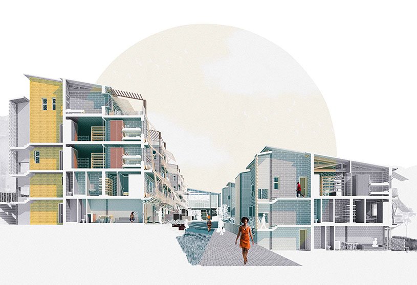
A double-axis strategy guides circulation, separating public and private paths while shaping layered edges between the city and the waterfront. A network of public walkways, interconnected ramps, and green roof spaces highlights movement and connectivity across the site. The building includes a composting facility, market hall, greenhouse, and café/bar—all arranged to encourage open and fluid circulation.
Located in Red Hook, Brooklyn, this project employs a double-axis design strategy to address site-specific conditions while encouraging the exploration of pedestrian circulation. It aligns with the broader city initiative to create a continuous waterfront landscape corridor, advancing this vision through piecemeal private development.
Programmatically, ‘Urban Edge’ contains (1) an industrial urban composting facility, (2) a commercial greenhouse, (3) a public greenhouse, (4) a public market hall, and (5) a culinary educational facility.
Design Process
Form DiagramProgram DiagramCirculation Diagram
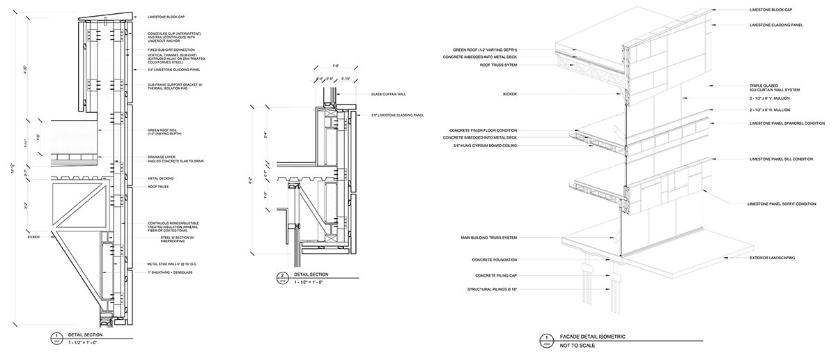
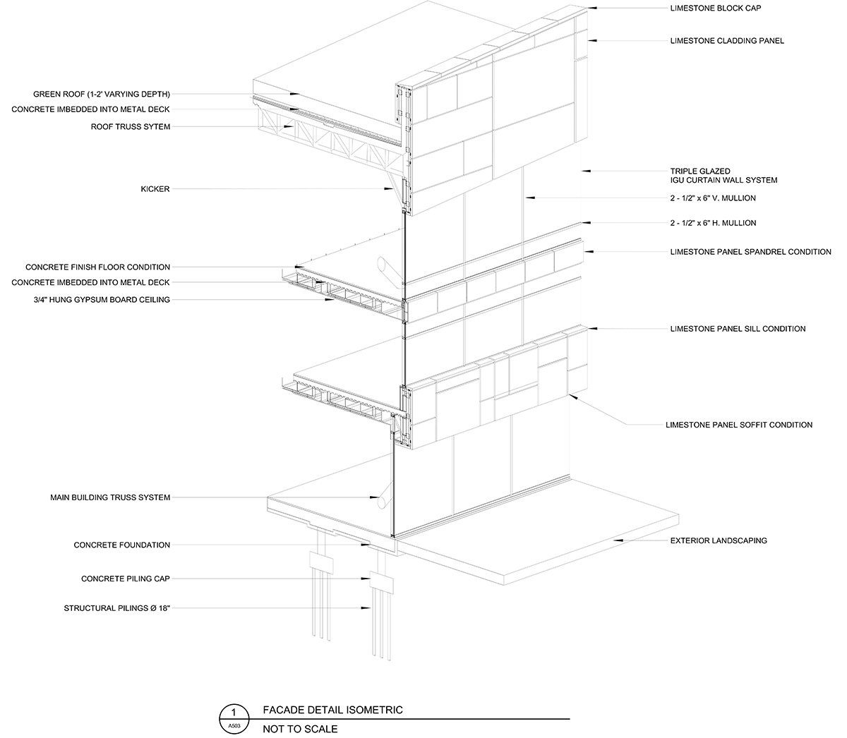
For the students, this studio marked their initial exposure to a range of technical and contemporary approaches in design and construction. Collaborating as a team, they engaged in weekly meetings with three specialized consultants: Corey Wowk (Facade Construction), Rick Naumann (Structural Engineering), and Bob Kearns (MEP Systems). These sessions enabled them to develop their most in-depth project so far, incorporating concepts of facade systems, structural integrity, and HVAC design.
Final Outcome
Site PlanFirst Floor PlanModel
A landscaped promenade runs along the shoreline, wrapping around the structure, extending into the water, and linking to a newly established ferry terminal. However, the primary focus of circulation occurs on the building’s green roof—a Möbius strip-like system of landscaped pathways that enables ascend and descend almost every part of the building. This fluid circulation design invites the public to engage with typically restricted industrial processes, such as composting and urban agriculture, while also offering expansive views, including the Manhattan skyline, the Statue of Liberty, and New York Harbor.
Second Floor PlanElevationsSections
Sectionally, the building explores ideas of synergy between the four programs. The process begins in the market hall, where food waste generated by vendors and patrons is collected and transported to the composting facility. There, both the market’s waste and additional organic material from the surrounding neighborhood are processed through multiple stages to create nutrient-rich soil.
The resulting compost is transported via a conveyor belt to both the public and commercial greenhouses, where it is used to grow produce. In addition, the composting process generates excess heat, which is mechanically captured and redirected to help regulate temperatures within the greenhouses. In the commercial greenhouse, the compost supports the growth of produce like lettuce and microgreens, which are later sold by vendors in the market hall below. Meanwhile, in the public greenhouse, the compost and redirected heat are used to grow native aquatic plants, which are eventually released into the harbor once fully developed.
RenderRenderRender
The building functions as an integrated system, with each component supporting and enhancing the others. It sustains itself by reusing internal resources while also accepting excess food waste from the surrounding community. In turn, it contributes to the local ecosystem by cultivating and releasing native wildlife along the adjacent coastline.
Model
Conclusion: Ultimately, the project creates a self-sustaining system that links ecology, community, and architecture, transforming waste into resources and reconnecting the neighborhood with its waterfront.
[This Academic Project has been published with text and images submitted by the student]
Site Context
Design Process
Final Outcome
To submit your academic project for publication at ArchiDiaries, please visit the following link >> Submit
Get the best of ArchiDiaries, directly in your inbox.
We use cookies on our website to give you the most relevant experience by remembering your preferences and repeat visits. By clicking “Accept All”, you consent to the use of ALL the cookies. However, you may visit "Cookie Settings" to provide a controlled consent.
This website uses cookies to improve your experience while you navigate through the website. Out of these, the cookies that are categorized as necessary are stored on your browser as they are essential for the working of basic functionalities of the website. We also use third-party cookies that help us analyze and understand how you use this website. These cookies will be stored in your browser only with your consent. You also have the option to opt-out of these cookies. But opting out of some of these cookies may affect your browsing experience.
Necessary cookies are absolutely essential for the website to function properly. These cookies ensure basic functionalities and security features of the website, anonymously.
Cookie
Duration
Description
cookielawinfo-checkbox-analytics
11 months
This cookie is set by GDPR Cookie Consent plugin. The cookie is used to store the user consent for the cookies in the category "Analytics".
cookielawinfo-checkbox-functional
11 months
The cookie is set by GDPR cookie consent to record the user consent for the cookies in the category "Functional".
cookielawinfo-checkbox-necessary
11 months
This cookie is set by GDPR Cookie Consent plugin. The cookies is used to store the user consent for the cookies in the category "Necessary".
cookielawinfo-checkbox-others
11 months
This cookie is set by GDPR Cookie Consent plugin. The cookie is used to store the user consent for the cookies in the category "Other.
cookielawinfo-checkbox-performance
11 months
This cookie is set by GDPR Cookie Consent plugin. The cookie is used to store the user consent for the cookies in the category "Performance".
viewed_cookie_policy
11 months
The cookie is set by the GDPR Cookie Consent plugin and is used to store whether or not user has consented to the use of cookies. It does not store any personal data.
Functional cookies help to perform certain functionalities like sharing the content of the website on social media platforms, collect feedbacks, and other third-party features.
Performance cookies are used to understand and analyze the key performance indexes of the website which helps in delivering a better user experience for the visitors.
Analytical cookies are used to understand how visitors interact with the website. These cookies help provide information on metrics the number of visitors, bounce rate, traffic source, etc.
Advertisement cookies are used to provide visitors with relevant ads and marketing campaigns. These cookies track visitors across websites and collect information to provide customized ads.